| Axis and Allies Map Thread: 2012-03-04 16:42:00 |
Flypurplehamster
Level 2
Report
|
So, I’m working on an Axis and Allies map (well, now it’s more of a WW2 map). It will have a map of the world, and, to make the European theater easier to see and have more territories, there will be a large rectangle with Europe in it showing what is going on in that theater from which you would control European forces.
I’m thinking about doing the same with the Pacific theater, even though there are much smaller bonuses at stake.
Anyway, some questions for you guys:
Should territories like Turkey and Switzerland, which were neutral in WW2, be unplayable, or be territories that can be modded to have 10,000 neutrals in them and thus be unplayable anyway (if so desired)?
Does giving two Inkscape groups the same id make them act like the same territory, or just mess Warlight up?
|
| Axis and Allies Map Thread: 2012-03-04 17:03:28 |

Matma Rex 
Level 12
Report
|
|> Does giving two Inkscape groups the same id make them act like the same territory, or just mess Warlight up?
It won't work, but you can select multiple shapes and use Path -> Union to merge them into one.
|
| Axis and Allies Map Thread: 2012-03-04 17:19:25 |

 Ironheart
Level 54
Report
|
if it is allies and axis then only allies and axis countries only
|
| Axis and Allies Map Thread: 2012-03-04 17:21:34 |
RvW
Level 54
Report
|
|> Should territories like Turkey and Switzerland, which were neutral in WW2, be unplayable, or be territories that can be modded to have 10,000 neutrals in them and thus be unplayable anyway (if so desired)?
You could leave them out (just like oceans, they're not a territory) or you could include them, then leave them out of the default distribution mode (that will not make them wastelands however, for that you need a custom scenario).
Either could work, it's up to the map designer to decide what he prefers. :)
ps. Putting 10.000 neutrals in them will be effectively the same as not including them; even on USA Big (after taking most of the rest of the map and having lots of reinforcements) it would still take considerable effort to break a 10.000 army wasteland. I'd suggest anywhere between, let's say 100 and 500 (also depending on how big the rest of the map is) would be a reasonable value: you don't want to have to break through, but if really necessary, you can.
|
| Axis and Allies Map Thread: 2012-03-04 18:07:11 |
Flypurplehamster
Level 2
Report
|
While I did not use Path-->Union, I did merge objects into single groups, which were then called “Territory_1”, “Territory_2”, etc.
@RvW: I was wondering, however, if I should make (for example) Spain’s usability configurable to the user or not, by making it a regular territory or not.
That way, one could use a world map containing a detailed map of Europe/Mideast/Mediterranean with every territory fully configurable for simulations of other wars besides WW2.
|
| Axis and Allies Map Thread: 2012-03-04 20:12:24 |

Addy the Dog
Level 62
Report
|
i think you should leave neutral countries greyed-out.
|
| Axis and Allies Map Thread: 2012-03-04 21:04:59 |

Moros
Level 50
Report
|
Grouping is not merging. You should never do it, because it confuses the map creator. Please, just use the union tool RvW described, as it is the only tool giving proper results easily! (Or you can try it [the hard way]( http://warlight.net/Forum/Thread.aspx?ThreadID=3075&Offset=13).)
|
| Axis and Allies Map Thread: 2012-03-04 21:10:05 |
Flypurplehamster
Level 2
Report
|
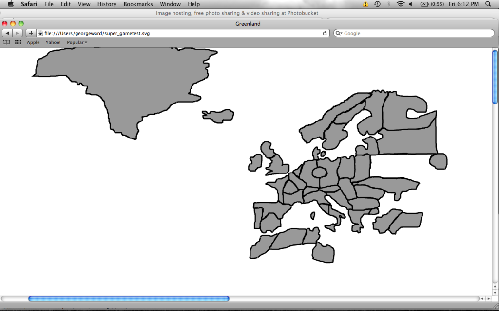
Thanks, Moros. I figured that out when I tried to upload my map for testing. And, here it is so far!
http://warlight.net/SinglePlayer.aspx?PreviewMap=11117
|
| Axis and Allies Map Thread: 2012-03-05 02:15:45 |

i-like-swords
Level 31
Report
|
Just a suggestion: can you please make the territories within Europe a little more historically accurate? The Austrian-Hungarian Empire was larger than what you have, and if you are talking about WW2, then you should have Hungary further south, Bohemia and Moravia, and Slovakia as separate territories. Also, outline the zoomed in map of Europe to make it easier to distinguish.
|
| Axis and Allies Map Thread: 2012-03-05 02:56:29 |
Flypurplehamster
Level 2
Report
|
I always figured WW1’s Austria-Hungary controlled territory outside of Austria and Hungary, and that was why it was so much bigger. Is this not the case?
My Hungary is an amalgamate of the Czech Republic and Hungary proper, though it does need to be bigger. Is such an fusion horribly historically inaccurate?
I didn’t want the European front to get mopped up in Central European campaigns, like the regular Europe map does. Is there a historical reason that Bohemia, Moravia, and Slovakia should be added?
|
| Axis and Allies Map Thread: 2012-03-05 23:39:39 |
i-like-swords
Level 31
Report
|
Well, in WW1 Austria controlled Bohemia and Moravia, which is known as the Czech Republic. Where it is supposed to be is occupied by Eastern Germany. Hungary is fairly accurate, although it is missing the territory of Transylvania, which was awarded to Romania after the war. Romania appears to be missing here, overtaken by Bulgaria and Ukraine. Croatia, Slovenia, and Bosnia were part of the Austrian Empire before WW1 while Serbia and Montenegro were independent kingdoms, not being unified into Yugoslavia until after WW1. I'm okay with Yugoslavia though, but I just wanted to point out some historical inaccuracies.
|
| Axis and Allies Map Thread: 2012-03-06 01:16:20 |
Flypurplehamster
Level 2
Report
|
What looks like Ukraine to you is actually Romania. I moved it a bit north for bordering reasons: I’d prefer borders to be obvious rather than not.
Would you suggest I shrink Eastern Germany and turn Eastern Germany’s south bit into part of Austria or make it independent and call it Moravia?
This is WW2, not WW1. I meant it to be somewhat compatible with WW1, however. Would making the western Balkans one territory mess that up strategically?
|
| Axis and Allies Map Thread: 2012-03-06 16:35:47 |
Ironheart
Level 54
Report
|
moros i later found the union button and used the hard way once
|
| Axis and Allies Map Thread: 2012-03-09 03:54:03 |
Flypurplehamster
Level 2
Report
|
Hey, everybody: what is your opinion as to whether the Caspian Sea should be a sea territory?
|
| Axis and Allies Map Thread: 2012-03-10 01:20:42 |
Flypurplehamster
Level 2
Report
|
Tech support please: My map can’t be brought to Warlight for editing (Europe is pretty much finished) because there’s supposedly too much information. I only have drawn items in Inkscape: the maps I’ve been using as tracing paper have been deleted for the purpose of uploading.
Here is my map so far:
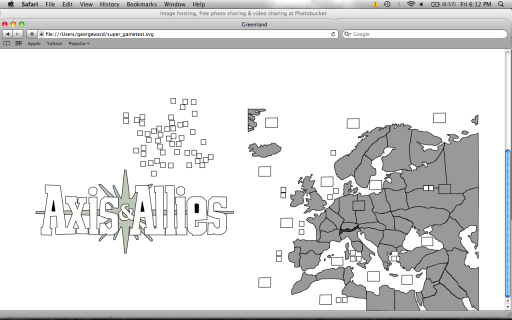
Any idea what I should delete?
|
| Axis and Allies Map Thread: 2012-03-10 01:22:41 |
Flypurplehamster
Level 2
Report
|
|
| Axis and Allies Map Thread: 2012-03-10 13:33:35 |
 Grzechooo
Level 32
Report
|
Have you tried simplifying? (e.g. select all paths and click Ctrl-L)
|
| Axis and Allies Map Thread: 2012-03-14 21:31:22 |
Flypurplehamster
Level 2
Report
|
Thanks, Grzechooo.
http://warlight.net/SinglePlayer.aspx?PreviewMap=11117
I’m having a problem with small slices of my territories disappearing every time I click once I download to Warlight. Clicking on the territories restores them, but territories will often disappear entirely.
Any way to fix this?
|
Post a reply to this thread
Before posting, please proofread to ensure your post uses proper grammar and is free of spelling mistakes or typos.
|
|
